Weeks three and four, Arizona Trail
Well Flagstaff to the Mt Peeley trailhead (in the Mazatzal Mountains west of AZ 87, between Sunflower and Rye), was my longest stretch on the trail yet, at two weeks. Pertinent observations are:
1) Crossing AZ 87, near the Blue Ridge ranger station, NE of Clint's Well, was a watershed in terms of number of people seen and social interactions. I saw day hikers, picnickers, mountain bikers, even five more AZT thru hikers, from this point to the Mt Peeley trailhead. I had a beautiful morena jump out of a car, run over and hand me a beer, a turkey hunter invite me to his camp for dinner and two women car-campers load me up with water. On top of this, my friends Dennis and Dusty Wagner joined me near the Rock Crossing campground with beer, a full-on KFC dinner with all of the trimmings and a camp chair to sit in. What a luxury! We then backpacked together from there up to the edge of the Rim, down to Washington Park and along the Highline Trail to Webber Creek. At that point they caught a ride (with a very nice couple....section hikers who had actually seen me three weeks earlier up in the Babbitt Ranch area north of Flag) back to their car and I continued on to Pine, which ended up being a grueling slog.
2) The section of the AZT I hiked with Dennis and Dusty is the prettiest I'd hiked since the Grand Canyon. There is actually running water! I didn't realize how much I'd missed that sound, which I hadn't heard since the aforementioned gorge. General Springs Canyon, atop the Rim, was beautiful and then below the Rim were the East Verde, Chase Creek, Sycamore Creek, Bray Creek, Bear Spring and Webber Creek. And in a setting reminiscent of Sedona, without the crowds, traffic or gift shops selling pink coyote tee shirts and teal Kokopelli mugs. I'll be back to this bit of heaven for day hikes in succeeding summers.
3) Payson is not just a 4 mile long strip mall! This epiphany came thanks to my old friend Greg McKelvey, who picked me up at sundown on Sunday, October 8 at the Pine trailhead. What a sight for sore eyes his red pickup was after a arduous day on the trail (Webber Creek to the Pine Trailhead was an interminable series of ups and downs without the running water I'd seen earlier in the day, although there were some pretty stands of Arizona Cypress)! He and Sally wined and dined me like royalty, while we caught up on each others lives. Monday morning we had delicious sourdough pancakes, then Sally departed for Phoenix. I'd completely forgotten about Columbus Day, which meant that I couldn't pick up the resupply package I'd mailed myself to the Pine post office till Tuesday morning. So Greg kindly offered to give me his Pine-Payson creative personality tour. He started with photographer Nick Berezenko of Pine who, in addition to being outstanding at his craft, is a meticulous observer and naturalist. I gleaned more from his annotated 7.5 minute quads of the Mazatzal Mountains than from a stack of guidebooks. We drove to Payson and toured old Main Street and the Green Valley Park area, both much more interesting than the gas stations and fast food joints on highway 87 that had colored my previous opinion of Payson. Then I met Pete Aleshire, the editor of the Payson Round-up, and some of his staff, who are doing excellent reporting on things like wildfires in the Rim Country and what can be done to lessen their severity in the future. Great to see a small-town newspaper that isn't just a free advertising rag, but actually pursues high-quality investigative journalism! Finally I went to a photography club meeting and saw some very nice work as well as getting to know more interesting Paysonians. Greg, you convinced me: Payson's got a heart!
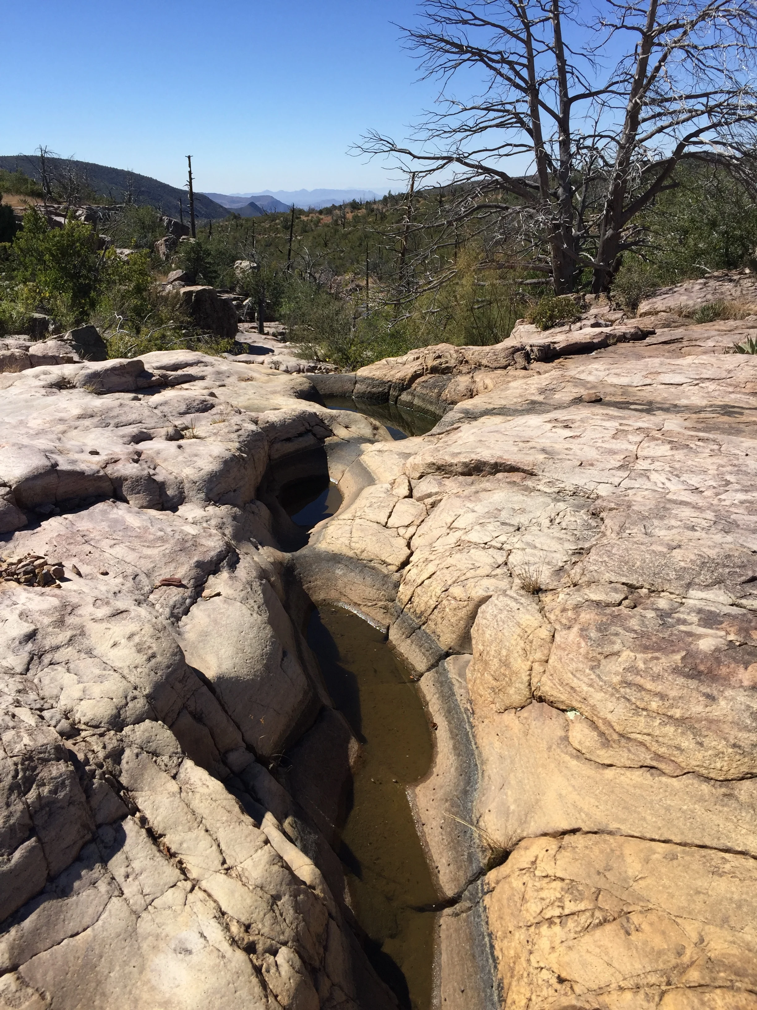
4) I now know how to pronounce Mazatzal (I think)! One of the photographers at the photo club meeting Greg took me to, who works at the eponymous casino on the outskirts of Payson, told me you just slur together "mad as hell" and that it is Apache for "mountains with many deer". This range loomed on the southern horizon as my next big challenge after leaving Pine. Well, I didn't see many deer there and I saw even less water. I'd packed nearly a gallon up the AZT into the Mazatzals from the LF Ranch on the East Verde (a beautiful spot, and many thanks to my host Shawn and his boss, Maryann) and after 3,000 ft of vertical climb on a pretty warm day, was down to a measly 1/2 cup by nightfall. All of the springs and seeps shown on the map were bone dry. Eventually a northbound hiker came by my camp at dusk and when I queried him about water where he'd come from, he reassured me that both Horse Corral Seep and Bear Springs were good. I was very relieved to here this, as my swollen tongue was stuck to my palette like velcro and I'd been formulating a Plan B to bail out down Barnhardt Canyon to 87 if Horse Corral failed me. That said, next morning's hike was damned unpleasant, I was horribly thirsty (and hungry to boot, as I had no water to mix with my dried foods), and it took me nearly three hours to reach the spring. Another southbound thru hiker who'd also passed my camp at sunset the previous evening (and had left the East Verde with only 2 liters of water so, if anything, was thirstier than I was) was camped there. He showed me the nice deep tinaja in the quartzite creek bed which held a few hundred gallons, then pushed off ahead of me. I filled my menagerie of containers with cool water, purified it, drank a liter as soon as it was ready, then filled up again before heading off for Bear Springs a much happier camper. My overall assessment of the Mazatzals: rugged as hell, probably a wildlife and hikers paradise before the 2004 Willow fire destroyed their forest cover and resulted in severe degradation of major watersheds, but now desperately dry, covered in manzanita and pin oak, and unforgiving.
5) My preferred trajectory for the Palatwaki Trail/Chavez Pass Trail, the ancient trade and migration route that connected the Verde Valley with the Hopi Mesas, would pass through Pine Spring and Bargaman Park, located near each other between Mormon Lake and AZ 87. Both places have water, lots of tall grass, abundant wildlife (elk bugling all night). And I saw what looked like some ancient tumbledown stone walls at an un-named location along the route nearby. I'm already thinking of a future hike to try and trace this route in detail!
6) Mormon Lake currently has little evidence of its LDS heritage...the name comes from a dairy farm the church established there in the mid 1870s that is long gone. It's now a community of summer homes for climate refugees from Phoenix, with a trailer park, lodge and cabins for even-more-transient folks like hunters and AZT hikers. Unfortunately the restaurant is only open Thursday through Sunday in the fall. I was there on a Tuesday so had to fall back on microwaved junk food from the freezer case in the convenience store/post office in lieu of the steak dinner I'd dreamed of. Which turned out to be OK, as I had entertaining visits with Carl and Jeff, two twenty-somethings working the cash register there.
7) Finally, here is my seriatim list of which rocks/formations make the best to worst trail conditions: the Permian Schnebly Hill Formation/Supai Group, the Proterozoic granites and rhyolites of the Mazatzals, the Proterozoic slates of the Mazatzals, the Permian Kaibab Limestone, the Mississippian Redwall Limestone, the Permian Coconino Sandstone, the Proterozoic quartzite of the Mazatzals and finally, bottom of the list, worst of the lot and unfortunately most abundant: the Miocene to Recent basalts.